Gorge East
Carthage
Crossing the Driving Park Bridge brings you into the early settlement of Carthage. In early Rochester, materials were shipped north from the vicinity of the Lower Falls of the Genesee River. Initially material was shipped from King's Landing but it was decimated by the Genesee Fever and fell into disfavor. In 1817 a group of investors led by Elisha Strong bought 1000 acres of land on the east side of the Genesee River near the Lower Falls. The approximate boundaries of the property using present day streets were: the Genesee River on the west, just past North Clinton Avenue on the east, Clifford Avenue on the south and several blocks past Ridge Road East on the north. Their idea was to use the water power of the Lower Falls for manufacturing and ship the products from Carthage Landing, later Brewer's Dock, at the bottom of the Switchback Trail near the present Seneca Towers. This would be more efficient than shipping goods from the area of the Upper Falls. The settlement grew quickly.

Centennial History of Rochester, NY Volume II, Home Builders, 1932 Pages 227-243 related to Carthage
At the time, if you were traveling across what became Ridge Road East and West, how did you cross the gorge of the Genesee River? You turned south and crossed at the Main Street bridge which was built between 1810 and 1812 and the only bridge in the 20 miles between Lake Ontario and Hartford (Avon). The people at Carthage felt travelers would by-pass their settlement and go directly to the Main Street bridge. They decided a high bridge should be built at the Lower Falls. An article in Rochester History by Joseph Barnes tells this story.
The fate of Carthage was sealed when it was decided to build the Erie Canal through downtown Rochester. The Erie Canal opened in late 1825. In partial response, in 1832, Rochester's first railroad was built from Carthage to the Erie Canal. The cars rode on rails and were pulled by horses. When Rochester became a city in 1834 Carthage was absorbed and the Carthage Railroad discontinued in 1838.
Additional information about Carthage in Windows to Rochester, Rochester School for the Deaf, 1984.

The Port of Rochester, five miles south of Lake Ontario, at the north line of the city.

Henry O'Reilly, Sketches of Rochester, opposite page 348
VIEWS ON THE GENESEE IN ROCHESTER
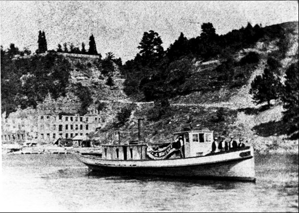
Carthage Landing is seen over the boat. Note the Switchback Trail to the left of the smoke and the incline rails to the right.

Carthage Landing after fire.
Carthage Landing became a center for tanneries. Tree bark brought from Canada lined the river bank. In 1858 the bark caught fire and destroyed the tanneries. Eventually the tanneries were torn down and the stone used as ballast for the first Summerville pier. This picture shows Carthage Landing, the Switchback Trail and the burnt tanneries. Date and origin not known. Possibly a stereoview.
History Paints Old River Dock Alluring Color
The Carthage fountain was at the intersection of St. Paul Street and Norton Street.
Kodak Hawkeye Plant
The plant is at the NE corner of the Driving Park Bridge. The 1890's were a time of great activity in the photographic field. The development of flexible film replacing glass plates, cameras getting smaller and the manufacture of a variety of printing papers led many companies to organize during this period. Two Kodak chemists, who had worked on flexible film, left the company and joined with a camera maker to form the Photo Materials Company in 1892. Their company was the first to be located on this site. While a period of great photographic activity, the 1890's was also a period of financial instability. Many of the new manufacturers decided to sell and take a small profit. Eastman bought the Photo Materials Company, the Boston Camera Company and the Blair Camera Company. In 1902 Eastman moved all three companies into the Photo Materials Building. The Hawkeye name came from Blair. The best book on this period is Reece Jenkins, Image and Enterprise: Technology and the American Photographic industry, 1839 to 1925. A book by Dr. Rudolf Kingslake has much information on Rochester camera companies.

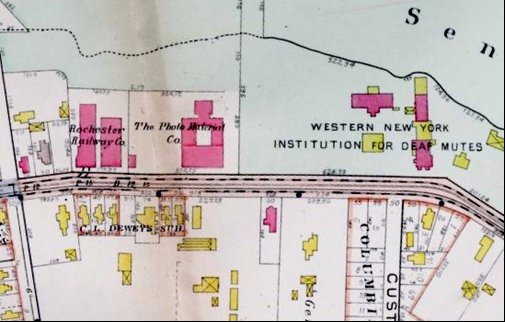
1900 - Photo Materials Company

1910 - The Photo Materials building was renamed the Blair Camera Company.


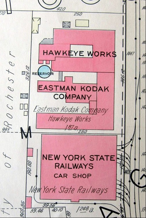
1935 - Hawkeye Works
The 1935 map shows the New York State Railways Car Shop. On a later map this is shown as US Government property. The property was eventually acquired by Kodak and the present large building built. The Google Maps street view.
The building was used for lens making and special projects.
An example of a special project was Bridgehead.
- Hawkeye Works Kodak Spy Plant
- Bridgehead: Eastman Kodak Company's Covert Photoreconnaissance Film Processing Program
Rochester School for the Deaf

St. Paul Street Campus

Original Campus Area - NE corner South St. Paul and Court Street
The Rochester School for the Deaf
Windows to Rochester, Rochester School for the Deaf, 1984
Riverside Park

From the Rochester Union and Advertiser, March 13, 1895. The Park was likely east of St. Paul and north of Norton.
For information on baseball in Rochester visit the Rochester Historical Baseball Society website.
Seth Green
The father of artificial fish propagation is associated with Carthage. It's said he conducted many of his experiments on Seth Green Island which is on the Genesee River just south of the Veterans Memorial Bridge. The story is told in Seth Green Father of Fish Culture, Rochester History, July 1944. There is an informative plaque on the north side of the Seth Green Fishing Access parking area.
Switchback Trail

Switchback Trail in the center of the picture leads from Seth Green Drive down to the Genesee River (here Brewer's Dock). The Veterans Memorial Bridge and St. Paul traffic Circle are in the upper right. Picture is from a 1935-36 plat map.

Sign on the west side of Seth Green Drive

Photo taken by Mike McBride using a drone. Notice the Seneca Towers in the lower left and the snow covered Switchback trail in the center left. Seth Green Island is in the very top right.

Looking at Carthage (Brewers) Landing and the Switchback Trail from the west bank of the Genesee. Picture from a stereoview card.
Veteran's Memorial Bridge

Rochester City Hall Photo Lab
Aerial view of the Veterans Memorial Bridge, circa 1940.
Myron Holley
The north east corner of St. Paul Boulevard and West Ridge Road was the location of Myron Holley's 120 acre property named Rose Ridge. Holley was selected to the canal commission in 1816 and was involved throughout, overseeing the construction of the western section. He became a staunch abolitionist and has been called the father of the Liberty Party, the first political party to run an abolitionist candidate for President. He moved to Rochester in the middle 1830's and in 1839 began his abolitionist newspaper, Rochester Freeman, there. Frederick Douglas in his autobiography. Life and Times, writing of his coming to Rochester, says, "The ground had been measurably prepared for me by the labor of others - notably by Hon. Myron Holley, whose monument of enduring marble now stands in the beautiful cemetery at Mount Hope upon an eminence befitting his noble character." Holley passed away on March 4, 1841. On June 13, 1844 the Liberty Party dedicated a monument to him at his plot in Mt. Hope Cemetery before 6,000 attendees.
Information on Myron Holley's life can be found in Pioneer Profiles by Arch Merrill ca. 1957. Scroll down to Chapter 17, Gentle Iconoclast. An article on his time in Rochester was printed in the Fall 2005 issue of the Crooked Lake Review and a biography by a local author was published in 2013.
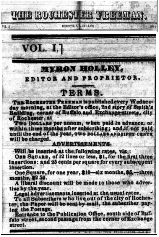
The Rochester Freeman was published from June 12, 1839 to December 25, 1839. From The Rochester Freeman, June 12, 1839. "The Editor's office is, in Smith's building, south side of Buffalo street, second stairs west of the corner, and opposite to the Eagle Tavern."

James Hardy
In May of 1897 the Toronto wire-walker James Hardy, aka Young Blondin, came to Rochester and for two weeks presented wire-walking demonstrations on a wire strung between East and West Seneca Park.
May 20, 1897 A Dinner Party in Mid Air
Windows To Rochester, Rochester School for the Deaf, 1984 p. 46
Seneca Park
For information on the formation of the park system see
A Growing Legacy - Dr. Blake McKelvey
A park Commission independent of the city was formed by an act of the State Legislature on April 17, 1888. One stipulation was that the Commission would prepare periodic reports on its activities. Several of these reports have been digitized by the Monroe County Library System and can be downloaded from their web site.
- Report of the Board of Park Commissioners 1888-1898
- Report Rochester Park Commission 1888-1904
- Park Commissioners Report Roch NY 1904-1905
- Rochester Park Commissioner 1911 Report
See the original document for information on Seneca Park.

This section of the 1935 plat map gives an idea of the location of Seneca Park relative to Riverside and Holy Sepulchre cemeteries and St. Bernard's Seminary.
The zoo's current renovation and expansion plans can be found here.
Irondequoit Flats
The Flats are a bowl that was cut in the east bank by a meander of the Genesee River as it was seeking its natural course. It was known as a farming area and the site of Gustav Rollers horseradish farm. From the aerial view you can see the part north of Seneca Park Avenue is largely open land and that on the south has been developed.

Rifle Range
Note that the Rifle Range is at the point between the railroad and the river bank are the narrowest. If you go through the fence to look at the tracks (no longer there) you will notice the rail bed accommodates two trains. One set of rails was a siding for trains bringing people to the Rifle Range.
The Irondequoit Story - Maude West - 1957
Day on the Genesee river with a stop at the Rifle Range, Windows to Rochester, Rochester School for the Deaf, 1984.


Rattlesnake Point

The City of Rochester and vicinity, Watkyns Publishing, 1911 p. 41
Rattlesnake Point

Note the two buildings at Rattlesnake Point, one being on the river.
O'Rorke Bridge

Albert R. Stone Negative Collection - Rochester Museum and Science Center, Rochester, NY
Stutson Street Bridge 1917
The boat landings were in the vicinity of the Lower Falls. Residents wanted a bridge but others argued it would interfere with shipping. A bridge at Charlotte wasn't built until 1917. The Stutson Street Bridge was replaced by the O'Rorke bridge in 2004.

October 2, 2004 - dedication of the O'Rorke Bridge - Stutson Street bridge in foreground, Hojack Swing Bridge in the river and "The Cat" fast ferry to its left

Removing the Stutson Street Bridge 10-29-2004
The Hojack Line swing bridge is in the center of the river in the upper right and the Cat fast ferry is to its right.
Hojack Swing Bridge

Looking south - Hojack Swing Bridge - in the distance are the Stutson Street Bridge(closed) and the O'Rorke Bridge(open)
A historical marker is located on the west side of the river.
- The Hojack Railroad Swing Bridge - The Historical Marker Database
- The Hojack Line Story - Friends of Webster Trails
- A Steppingstone of Civilization: The Hojack Swing Bridge and the Negotiation of Social Power in Monroe County, Western New York State